 I had an opportunity this week-end to go visit a spot I've wanted to visit for some time: Boundary Monument 0, the Middle Point. This is the southwest corner of the state of Delaware, where the boundary between Delaware and Maryland turns north.
My older daughter had plans Saturday evening for a sleep-over at a class-mate's house. Because she attends the county-wide technical high school, and has since middle-school gone once a week to Academic Challenge classes at the local community college, my daughter has very good friends in all corners of Sussex County. Her sleep-over this weekend was at a farmhouse west of Seaford, almost at the state line near Woodland Ferry.
After I dropped her off, I took advantage of the sunlight and did a bit of exploring. I wanted to see the Woodland Ferry, which has recently shut down and will be replaced with a larger boat. The ferry crosses the Nanticoke River at a small old settlement called Woodland, south of Seaford.
From there, I followed a small road along the west bank of the Nanticoke River, heading downstream towards Maryland. The road got smaller and smaller, following the edges of farm fields until it turned abruptly west, crossed a marshy creek, and entered Maryland. I had planned to use the smaller roads to cut through Galestown, cross the Nanticoke at Sharptown, and head south to pick up Route 54 at Mardela Springs, and so head back into Delaware at the Corner.
I came around a sharp bend in the road to Galestown, however, and came upon a pile of dirt, a parked crane and a clear denial of entry into town. Apparently, the Spillway at Galestown Millpond was washed out, blocking several routes through town. I had to backtrack north to Reliance and head west and then south the long way around.
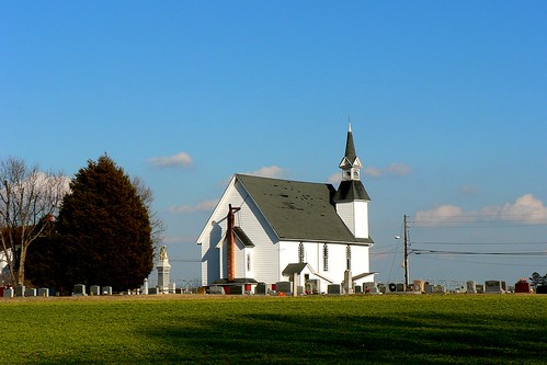 A pleasant surprise of this detour was a visit to Eldorado, Maryland. It included this noble church. That part of Delmarva has great wide-open fields and a slight roll to the landscape. Very impressive on a clear winter afternoon.
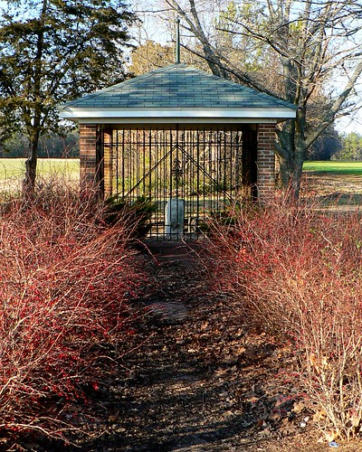
Eventually, I found myself rolling east on Route 54. Up ahead I spotted a small half-circle pull-off and the pavillion that protects the monument that marks the boundary. The Monument was placed by Mason and Dixon, to mark the start of the line they surveyed north and then west. They started their line at the Middle Point of a line surveyed across the center of the Delmarva peninsula by an earlier team. Their stone, inscribed with the coats of arms of Lord Baltimore and William Penn, joined several other boundary stones placed by earlier surveyors. In modern times, a Benchmark was added and officially recorded.
This is a part of Delaware 's history, and geography, that fascinates me. Part of my job is to work with the digital version of the boundaries and data that were started by Mason and Dixon, and folks like them, hundreds of years ago. Their chain of stones marking a north-south line up the peninsula is a part of the geospatial data that we rely on today and that I help to make available to Delaware's citizens.
So it was very cool to finally get a chance to go visit the first one.
No comments:
Post a Comment
Note: Only a member of this blog may post a comment.