We took a week and drove north to Highgate Springs, in Vermont, by way of Boston. We were on our way to visit Colleen, who is working this summer at the Tyler Place resort. We stopped in Boston on the way to tour Boston University and Emerson College with Christina.
View New England Trip, Summer 2012 in a larger map
A full photographic collection from this trip is on my flickr account. There are a few photos also posted on instagram.
Showing posts with label map. Show all posts
Showing posts with label map. Show all posts
Sunday, July 8, 2012


Monday, January 2, 2012
2011 Metrics: Golf
I managed to get out and play golf 20 times in 2011, playing at least once each month from April through (absurdly enough) the very last day of December. I played mostly in Delaware but a few times in the "mar" portion of Delmarva (Maryland) and once in Washington DC.
View Golf in 2011 in a larger map
I'm happy to report that my game, while still not very good, is no longer quite so embarrassing. I broke 100 (my goal for the year) in June at East Potomac Park, at Haines Point in DC. This was part of a memorable weekend of golf with my friends Andy and Rich; our wives teamed up to give us tickets to the US Open in Potomac, Maryland. We played on Friday and then watched our betters play on Saturday and Sunday.
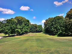 While I spread my game up and down the state, my "home course" has been Old Landing Golf club, outside of Rehoboth Beach. I played there eight times in 2011. Old landing is where I often go for a solo, contemplative practice round. It's not the greatest course in the world, but it is laid back, pleasant, inexpensive, and near by.
I hope to play at least as much golf in 2012. I spent time on golf courses with all of my golf friends in 2011, I hope to continue that trend and expand that circle.
View Golf in 2011 in a larger map
I'm happy to report that my game, while still not very good, is no longer quite so embarrassing. I broke 100 (my goal for the year) in June at East Potomac Park, at Haines Point in DC. This was part of a memorable weekend of golf with my friends Andy and Rich; our wives teamed up to give us tickets to the US Open in Potomac, Maryland. We played on Friday and then watched our betters play on Saturday and Sunday.
While I spread my game up and down the state, my "home course" has been Old Landing Golf club, outside of Rehoboth Beach. I played there eight times in 2011. Old landing is where I often go for a solo, contemplative practice round. It's not the greatest course in the world, but it is laid back, pleasant, inexpensive, and near by.I hope to play at least as much golf in 2012. I spent time on golf courses with all of my golf friends in 2011, I hope to continue that trend and expand that circle.
Saturday, February 19, 2011
Success! I Fixed A Google Maps Mistake. Now, For the Next One...
I got word from Google Maps today that they have accepted my correction to the location of the Judy V charter fishing boat. Google had shown it as a business located on the street outside our house, but it's actually based at the Indian River Inlet Marina, south east of here.
We live on Inlet Place, in Lewes. The Indian River Inlet Marina is on Inlet Road, south of Dewey Beach. Unfortunately, the road data that Google Maps has for Delaware doesn't include Inlet Road, so we tend to get identified as the location of things at the Inlet. For a short time, the offices of Delaware Seashore State Park were found (by Google, anyway) at our house. I think I sent a correction on that one as well.

I can't remember when I submitted the Judy V correction, but it's probably been less than a year. Back in April of last year, I gave a presentation on GIS and on-line mapping to a class of the Delaware academy of Lifelong Learning. I used my correction request as an example of what to be careful about with on-line maps.
It's not Google's fault, really. They are an aggregater of other data. They use state, federal or private sector aerial photography for their "satellite" view. They use crowd-sourced information for reviews of businesses and photos of places. And they use publicly available GIS data for roads, cities, waterways and the like. That Inlet Road is not on their maps yet speaks to a failure of what-ever mapping company they are using to provide road data to pick up Inlet Road.
 For the record, the Delaware DataMIL, which serves statewide road data for Delaware, does have Inlet Road.
Now that the Judy V's place-marker has been moved, I see that Google identifies our house as the local headquarters of the Coast Guard.
I guess I need to get back into correction-suggestion mode.
We live on Inlet Place, in Lewes. The Indian River Inlet Marina is on Inlet Road, south of Dewey Beach. Unfortunately, the road data that Google Maps has for Delaware doesn't include Inlet Road, so we tend to get identified as the location of things at the Inlet. For a short time, the offices of Delaware Seashore State Park were found (by Google, anyway) at our house. I think I sent a correction on that one as well.

I can't remember when I submitted the Judy V correction, but it's probably been less than a year. Back in April of last year, I gave a presentation on GIS and on-line mapping to a class of the Delaware academy of Lifelong Learning. I used my correction request as an example of what to be careful about with on-line maps.
It's not Google's fault, really. They are an aggregater of other data. They use state, federal or private sector aerial photography for their "satellite" view. They use crowd-sourced information for reviews of businesses and photos of places. And they use publicly available GIS data for roads, cities, waterways and the like. That Inlet Road is not on their maps yet speaks to a failure of what-ever mapping company they are using to provide road data to pick up Inlet Road.

Now that the Judy V's place-marker has been moved, I see that Google identifies our house as the local headquarters of the Coast Guard.
I guess I need to get back into correction-suggestion mode.
Thursday, April 3, 2008
What Did We Call This Place When?
In order to save electrons, allow me to point to a blog post I just wrote on the NSGIC Blog: Getting Serious About Original Place Names.
It is about a recent small grant by the Federal Geographic Data Committee to the state of Hawaii to add audio pronunciation guides to geospatial place-name data for that state. It builds on an idea developed by the Coeur d'Alene Tribe, in Idaho. The Tribe's GIS program has created audio map data, including for Google Earth and has entries outside of Idaho.
It is about a recent small grant by the Federal Geographic Data Committee to the state of Hawaii to add audio pronunciation guides to geospatial place-name data for that state. It builds on an idea developed by the Coeur d'Alene Tribe, in Idaho. The Tribe's GIS program has created audio map data, including for Google Earth and has entries outside of Idaho.
The project is open to input on names outside of traditional Couer d'Alene areas. Philadelphia, in Pennsylvania, for example, is at the same spot as what was once known as Tsi wahswèn:to (MP3) which translates as "at the coal forked mouth."I think this is a cool idea.
Subscribe to:
Posts (Atom)